

Co-directors Vito Messina (CST) and Jafar Mehrkian (ICAR)
The Iranian-Italian Joint Expedition in Khuzistan started the 2nd campaign in the area of Hung-e Azhdar, in order to develop the research begun in the 1st campaign (2008). This project falls within a 5 years Memorandum of Understanding, signed between the Iranian Center for Archaeological Research (ICAR) of the Research Organization of Iranian Cultural Heritage, Handicrafts and Tourism Organization (ROCHHTO) and the Centro Ricerche Archeologiche e Scavi di Torino per il Medio Oriente e l’Asia (CST). Other institutions involved in the project, as partners of the CST, are the Dipartimento di Ingegneria del Territorio, dell’Ambiente e delle Geotecnologie del Politecnico di Torino (DITAG) and the Dipartimento di Scienza dei Materiali dell’Università di Milano Bicocca (DSM). The Expedition was supported in Izeh by the Ayapir Cultural Heritage NGO.
Members of the Expedition were Mr. Jafar Mehrkian (ICAR, archaeologist and co-director), Mrs. Yalda Sourani (ICAR, architect), Mr. Mehdi Faragi (ICAR, archaeologist), Mr. Neamatollah Salashoor (archaeologist), Mr. Mojtaba Shokrollahi (photographer) and Mr. Ali Reza Ismaili (technician), for the Iranian side; Mr. Vito Messina (CST, archaeologist and co-director), Mr. Paolo Ardissone (DITAG, archaeologist and topographer), and Mrs. Cristina Bonfanti (DITAG, architect), for the Italian side. Supervisor of CST was Prof. Antonio Invernizzi. Supervisor of the DITAG was Prof. Fulvio Rinaudo.
The aims of the Expedition were:
– the acquisition by laser scanner of the natural surface of the Hung-e Azhdar rock relief and of the sculpted surface of the Hung-e Yaralivand and Hung-e Kavalvand rock reliefs;
– the topography of the valley of Hung-e Azhdar;
– the opening of trial trenches near the sculpted boulder of Hung-e Azhdar.
View this report in Adobe Reader format (without photos, 120 kB) |
View this report (with photos, 840 kB) |
The preliminary survey of the Hung-e Azhdar, Hung-e Yaralivand and Hung-e Kamalvand rock reliefs revealed the presence of targets for photogrammetry on the rock surface of all the sculpted reliefs. These are rectangular targets made of paper that have been fixed to the rock surface by a strong glue. These operations do not pertain to the present project and the relevant targets have been previously fixed on the rock. The presence of these targets has been reported to local Authorities by the Iranian co-director before starting our operations. During the preliminary survey of the Hung-e Azhdar rock relief clear traces of rainwater erosion have been detected on the surface: these are originated particularly by a long crack on the upper part of the boulder, that works as a natural pipe for the water flowing from the top of the boulder when it rains.
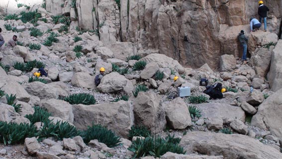
Acquisition by laser scanner lasted 4 days. The natural surface framing the sculpted relief of Hung-e Azhdar has been scanned with a resolution of about 1 mm. The acquired surface will be merged with the information provided by laser scanning of the sculpted surface, completed during the 1st campaign, in order to upgrade the 3D digital model of the boulder.
| Fig. 1 – Preparing for laser scanning at Hung-e Kamalvand. | |
 |
|
| Photo by J. Mehrkian | |
The rock relief of Hung-e Yaralivand depicts two standing men in frontal position, each dressed in a tunic with trousers. The lower part of each tunic is bell-shaped and the feet of the figures are turned in profile. The right figure has his left hand at his hip, while the left figure has his right to his hip. This relief is interpreted as a scene of investiture where the right man is investing a prince with his authority (Mathiesen, 1992, 123-124).
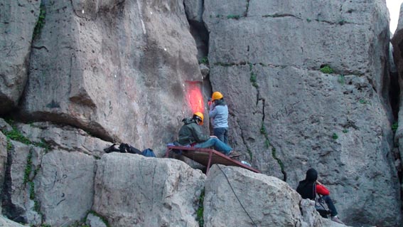
The sculpted surface of the rock relief of Hung-e Yaralivand has been divided into 9 squared sectors, each of about 60x60 cm. Markers were placed on the surface in order to allow the scanner to recognize its position in a 3D model. These markers are circular spots with a diameter of about 5 mm that have been completely removed after acquisition. Each sector has been separately scanned with a high definition handyscan (model HZ), a self-positioned hand-held scanner, perpendicularly moved at about 15-20 cm from the rock surface. The scanner never touched the surface during operation.
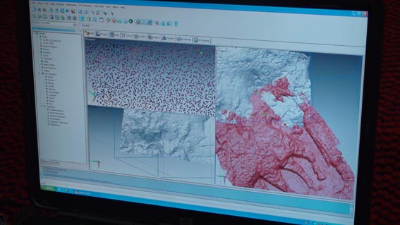
| Fig. 2 – Laser scanning of the Hung-e Kamalvand rock relief. | |
 |
|
| Photo by V. Messina | |
The rock relief of Hung-e Kamalvand has been acquired with the same technique and the sculpted surface has been divided into 9 square sectors each of about 50x50 cm. It depicts a standing figure wearing a long belted robe and facing a horseman proceeding to right. An Elymaean inscription runs on the upper part of the scene: “Phrates the priest, son of Kabnuskir” (Hinz, 1963, 171). It is generally assumed that this inscription refers to the horseman (Kawami, 1987, 72-73) and claims to a royal descent, while the standing figure remains unidentified. But it is possible that the inscription refers to the standing figure rather then to the horseman. According to T.S. Kawami (ibid., 73) this relief may depict a member of the Kamnaskired dynasty who retained some power perhaps religious, rather then political, in the Izeh valley.
The acquired frames of all reliefs have been merged in the laboratory of DITAG, with an accuracy of 0.2 mm approximately. Images with photogrammetric digital camera (model Kodak DCS PRO 14m) have also been acquired, that will update the information provided by the laser scanning. These have been elaborated in Turin, in order to obtain digital orthophotos and “Solid Images” of the scanned surface. Solid Images are digital images where all the pixels contain x, y, z coordinates, providing information in a known reference system so that it is possible to measure angles, distances and areas. Control points on the sculpted surface of the reliefs have been acquired by total station, in order to locate the merged frames in the same reference system. The accuracy of the grid has been verified by triangulation and intersections of the control points.
| Fig. 3 – Laser scanning of the Hung-e Yaralivand rock relief. | |
 |
|
| Photo by V. Messina | |
The complete 3D digital model of the Hung-e Azhdar sculpted relief and of the natural surface of the boulder is composed by 7.712.000 points, and is rendered by the software SirIO.
The 3D model of the Hung-e Yaralivand rock relief consists of 2.467.745 points, the 3D model of the rock relief of Hung-e Kamalvand consists of 2.378.347 points.
The preliminary elaboration of the data acquired in Hung-e Yaralivand revealed traces of an inscription on the upper part of the sculpted scene, that was not visible to the naked eye: indeed, this inscription has been deeply eroded and only scanty traces of some letters are detectable. It is an Elymaean inscription in Aramaic language of the south Mesopotamian group very similar to the well known inscription in Hung-e Kamalvand. This inscription has not yet been detected by other previous surveys and is still unpublished. The correct and final reading will be provided afterward by Prof. F. Pennacchietti (University of Turin) and Dr. Marco Moriggi (University of Catania).
A main network of 6 vertices has been fixed by total station (model Leika) following the valley ground: 5 of these vertices have been also acquired by GPS receivers (model Topcon Hiper PRO). Starting from these vertices a further network consisting of 2462 ground control points (GCP) has been fixed by total station on the ground and on the slopes of the valley: these points have been acquired in reflector mode (360° prism) and with reflector lens in order to define elevation by various levelled sections. Vertices and GCP have been acquired in a known reference system.
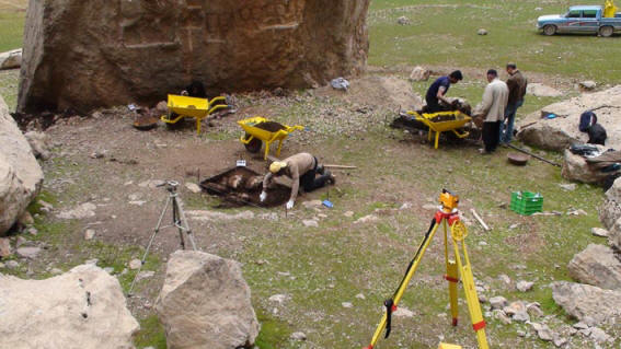
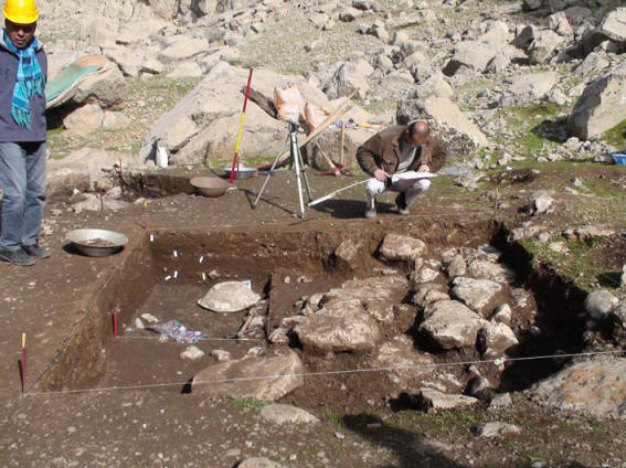
| Fig. 4 – Excavations at Hung-e Azhdar. | |
 |
|
| Photo by M. Shokrollai | |
The relevant map shows that the valley ground is at an elevation of 836-837 m above the sea level (ASL), approximately, and that the investigated area is at an elevation of about 842 m ASL, on the southern slope of the valley (maps 1-3). The area of archaeological interest covers about 4.200 m2 around the sculpted boulder and is located between 3533070-3533130 N and 392610-392690 E m UTM (corresponding approximately to LL: 31°55’43.58’’ N, 49°41’40.96’’ E coordinates).
| Fig. 5 – Excavations at Hung-e Azhdar. | |
 |
|
| Photo by M. Shokrollai | |
The area selected for trial trenches is located at the foot of the mountains surrounding the valley of Hung-e Azhdar, south from the sculpted rock relief depicting the scene of homage or investiture, and extends for about 140 m2. Here the ground slightly slopes towards the centre of the valley and a number of huge boulders, collapsed in antiquity from the mountains’ cliffs, stand over the present surface or are partially wedged in it. This area, denominated Area 1, was partially surveyed during the 1st campaign, revealing clear traces of unauthorized excavations. The first remark has been confirmed by a preliminary reconnaissance during the present campaign: at least 5 irregular holes and 1 trench were still visible on the ground near and far from the boulder, with loose earth heaped in small mounds beside each hole. This situation deeply disturbed the archaeological context.
|
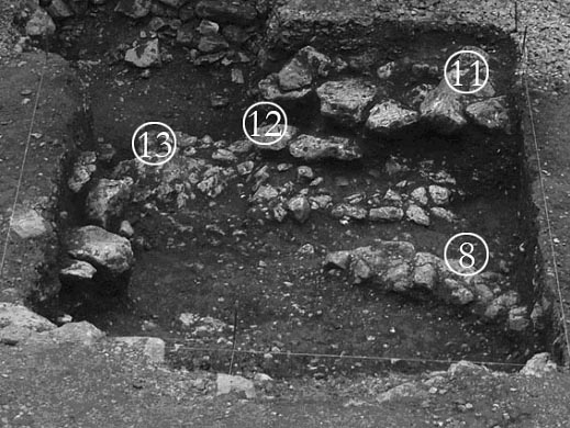
Fig. 6 – Trench HeA 1 003 from the South. |
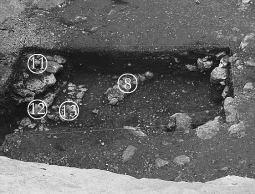
Fig. 7 – Trench HeA 1 003 from the West. |
 |
 |
| Photos by V. Messina |
Three small test-trenches (two of 4 m2 and one of 6 m2) have been opened and proceeding with the excavation two of these trenches have been unified in one trench of about 17 m2. These trenches, denominated HeA 1 001, HeA 1 002 and HeA 1 003, are close to the sculpted boulder: trench HeA 1 001 is about 3,5 m southeast of the boulder, trench HeA 1 002 is at its foot, on its western half, and trench HeA 1 003 were about 5 m south, almost in the centre of Area 1, but have been widened up to 1,5 m from the sculpted surface. Trench HeA 1 001 is a squared trench of 2x2 m, where the surface seemed untouched in modern times: here excavations started from the surface’s elevation of 842.208 m ASL. The presence of two huge stones hindered the prosecution of the works, while a further stone is of particular interest because it seems to have been placed on purpose, as it covers a layer containing potsherds that continues beyond the excavations’ limits. A gravel layer was reached below the potsherds layers: this covered a layer containing only stones at an elevation of 841.203 m ASL. Trench HeA 1 002 is a square of 2x2 m as well. Here a modern unauthorized trench deeply disturbed the archaeological context. In this trench a number of iron arrowheads and a ring with an engraved male head were found, but their pertinence is uncertain because of the modern hole. The same gravel and stones layers of trench HeA 1 001 have been reached at an elevation of 841.258-841.138 m ASL. Trench HeA 1 003 is the largest of Area 1, since it has been widened up to 5x3 m towards trench HeA 1 002 and unified with it, starting from a 1x2 m trench. Surface in this area revealed 4 modern holes that disturbed the underlying context.
For this reason, potsherds were not clearly stratified on the whole area, even if at least 3 main levels have been recognized in proximity of the eastern excavation limit. A number of arrowheads have been found in the northern part of the trench, close to the limits of trench HeA 1 002, together with fragments of handmade terracotta figurines representing horses. In this area, which is the nearest to the sculpted boulder, structures made in undressed stones have been unearthed close to the surface and also at a deeper level, but, since their remains continued beyond the excavation limits, they have not been completely cleared. Structure SU 11 is the closest to the surface, being at an elevation of 842.178 m ASL, and it consists of quite large stones gathered together in a quadrangular shape. This structure has been partially destroyed by the modern trench cutting the archaeological layers of trench HeA 1 002. SU 11 lies on structure SU 12, which is almost unknown because it is widely hidden below it. Structure SU 13 is the most ancient of them, being partially covered by SU 12. It has a rectangular shape and it is made of undressed stones smaller than those of the upper structures, probably cut for this purpose. Three corners of structure SU 13 have been cleared, showing that it recalls a small platform of 1.3x2.2 m, following the same orientation of the surface of the boulder and being less than 2 m from it. Potsherds were found in situ between the stones of the structures: they belong to a particular class of organic temper with dark core which indicates incomplete oxidation.
All trenches have been covered.
De Waele, E.
1975, “La sculpture rupestre d’Elymaïde. Deux fragments inédits d’époque
parthe”, Revue d’Assyriologie et d’Archéologie orientale, 69, p. 59-79.
Downey, S. B.
1977, The stone and plaster sculpture, (Excavations at Dura-Europos,
Final Report, III, I.2), Los Angeles.
Harmatta, J.
1981, “Parthia and Elymais in the 2nd century BC”, Acta Antiqua Academie
Scientiarum Hungaricae, 29, p. 189-217.
Hinz, W.
1963, “Zwei neuentdeckte partische Felsreliefs”, Iranica Antiqua, 3,
169-173.
Invernizzi, A.
1998, “Elymaeans, Seleucids, and the Hung-e Azhdar Relief”, Mesopotamia,
33, p. 219-259.
Kawami, T. S.
1987, Monumental Art of the Parthian Period in Iran, (Acta Iranica, 26),
(Textes et Mémoires, XIII), Leiden.
Mathiesen, H. E.
1985, “A note on the dating of the Parthian rock relief at Hung-i Nauruzi”, Acta
Archaeologica, 56, p. 191-196.
1992, Sculpture in the Parthian Empire. A Study in Chronolgy, I-II, Aarhus.
Messina, V., Mehrkian, J.
forthcoming, “1st Campaign of the Iranian-Italian Joint Expedition in Khuzistan.
Hung-e Azhdar (2008)”, Parthica, 12.
forthcoming, “First Preliminary Report of the Iranian-Italian Joint Expedition
in Khuzistan. Laser scanning of the Hung-e Azhdar rock relief and preliminary
survey of the surrounding area (campaign 2008)”, in Proceedings of the 10th
International Symposium on Iranian Archaeology, Bandarabbas (December 10-13,
2008), Tehran.
Schlumberger, D.
1970, L’Orient hellénisé. L’art grec et ses héritiers dans l’Asie non
Méditerranéenne, Paris.
Schmidt, E. F.
1970, Persepolis, III, The royal tombs and other monuments,
(Oriental Institute Publications, 70), Chicago.
Vanden Berghe, L.
1963, “Le relief parthe de Hung-i Naurūzī”, Iranica Antiqua, 3, p.
155-168.
1984, Reliefs rupestres de l’Irān ancien, Bruxelles.
Vanden Berghe, L., Schippmann, K.
1985, Les reliefs rupestres d’Elymaïde (Iran) de l’époque parthe,
(Iranica Antiqua Supplement, III), Gent.
Von Gall, H.
1969-70, “Beobachtungen zum arsakidischen Diadem und zur parthischen Bildkunst”,
Istanbuler Mitteilungen, 19-20, p. 299-318.
This page last updated 23 Feb 2021